Learning activity 2 – Duration and distance
Now that you know how to use Google maps, experiment with a variety of familiar locations and destinations.
Now, we will look at duration and distance.
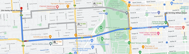
In the example above, with car as the mode of travel, there are three alternatives provided with different times and distances.
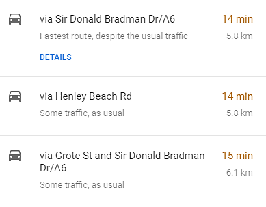
The car taking the most direct and shortest time would take 14 min with 5.8 km, from Adelaide to Henley Beach Road.
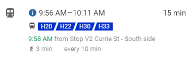
If you select another mode of travel like the bus, Google Maps will also provide the bus times (for example, 9:58 am from Stop V2 on Currie Street) and bus numbers (H30). Therefore the bus from Adelaide to Henley Beach Road will leave at 9:56 am at the location indicated and arrive 15 minutes later at approximately 10:11 am.
+
Task
- Search for directions from your home to a friend’s house or your favourite place to visit. Record the modes of transport, as well as how long it will take to get there (duration) and distance.
- Record your findings in a table. For example, if you travel from home to your friend’s house, can you see the differences between the different forms of transport? What is the most efficient way to get there?
Trip:
| Mode of transport | Distance | Duration |
|---|---|---|
| Car | ||
| Bus | ||
| Tram | ||
| Train | ||
| Walk | ||
| Bike |
Download attachment for an example table to complete:
(Or, you could also use an Excel spreadsheet to record this data.)
- Identify the landmarks or specific locations on your journey. What will you look out for to orient yourself?
- Identify landmarks wherever possible: streets, businesses, buildings, for example. How will you know where you are?
- Identify from Google Maps any major landmarks or businesses displayed on your route.
- Identify from Google Maps the major roads and intersections.
- Identify what walking you may have to do to catch a bus or other public transport.